Όταν διάβασα αναλυτικά το άρθρο του Γεωδίφη κατάλαβα επίσης γιατί αναφερόταν στο Μία σα νεκρό ποταμό. Επί χρόνια το νερό του Μέγα Ποταμού ακολουθούσε μία συγκεκριμένη διαδρομή προς τα χαμηλότερα τοπογραφικά σημεία. Με την ανάπτυξη και την επέκταση του χωριού οι γηγενείς άρχισαν να το βλέπουν σαν ένα μέσο διάθεσης αποβλήτων. Ήταν βολικός και το εγχείρημα απλό. Τα απόβλητα μέσα στο νερό δεν μπορούμε να τα δούμε. Σιγά-σιγά άρχισε να μετατρέπεται σε ένα τεράστιο αγωγό αποχέτευσης. Με τον καιρό το ολέθριο λάθος του Μεγάλου Ποταμού, να βρεθεί κοντά σε κατοικημένη περιοχή , αποτελεί ένα πρόβλημα το οποίο πρέπει άμεσα να αντιμετωπιστεί.
Τοπωνύμια της Νήσου Κω, Νικολάου Ζάρακα (Κωακά-Τόμοι Α' & Β' σ. 157)
Φωτογραφίες: Sophia Karagianni
MIAS RIVER, KEFALOS
I could not have imagined that there is such a large river on the island of Kos. I first saw a photograph of it by Geodifis, under the name Megas or Mias—a “dead” river.
The “Megas” I understood from its size, but the “Mias” (or Meias, according to Zarraftis) and the term “dead” raised many questions for me, so I began to look into it.
First of all, the word Mias probably derives etymologically from the word Megas, meaning large. There is another Mias river, smaller in size, in Kardamaina.
In Kefalos there are several small torrents. On its northern side, from Atsa to Kochylari, eleven flow into the sea, according to Zarraftis, and on the rest of its perimeter twenty-five, among which the Mias stands out as the largest. It is formed by streams to the west of the village and empties north into the sea, into the bay between Vounara and the Prasonisia islets.
According to Geodifis, the Megas River together with the Kalamos are the most important water systems of Kefalos. It springs from the small hill of Avgerinos (181 meters above sea level), located northwest of the ancient theater at the site of Palatia. It is about 4.3 kilometers long, and its course passes close to the community of Kefalos.
When I read Geodifis’ article in detail, I also understood why the Mias was referred to as a dead river. For years, the water of the Megas River followed a specific course toward lower topographical points. With the growth and expansion of the village, the locals began to see it as a convenient means of waste disposal. It was practical and simple: waste in the water cannot be seen. Gradually, it began turning into a huge sewage conduit. Over time, the fatal mistake of the Megas River—being located near an inhabited area—became a problem that must be immediately addressed.
On 22/10/2010, Kostas Kostoglákis presented the issue, which still persists. He specifically noted: “On a beautiful beach southwest of Kefalos, we discovered where all—or if not all, most—of its waste ends up. Sewage of all kinds, and mainly hazardous chemical waste, flowing ceaselessly over a distance of about 3 kilometers, ending in the sea. The stench is intense in an otherwise protected area…”
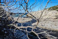
Nevertheless, the landscape is of unique beauty, and we approached it on two different occasions under different weather conditions. The first time, Dimitris Antonouris led us from Kefalos, in strong wind, along a relatively short route descending from above toward the sea at the pocket beach of Vitsikos.
On the small beach we were faced with a stormy sea, with wild waves crashing against the steep rocks.
The second time we went to the Mias River, we started along the coast from Limnionas, on a sunny day when not a leaf was moving. The colors and reflections were unique.
In both cases, the Mias was a magnificent sight, which I am certain very few people of Kos have enjoyed—and which should by no means be spoiled by human intervention.


Δεν υπάρχουν σχόλια:
Δημοσίευση σχολίου